
Yesterday was the four month anniversary of the closing of the Mannahatta exhibit at the Museum of the City of New York. Do I sound like I'm in mourning? I miss it.
 [Credit: petit hibout, Flickr.com]
The exhibit deftly wove together three themes that have emerged in my own life and journalism: peeling back layers of history, a connection with nature in urban areas, and information display.
There's a nice description of the display space at the web site of Pentagram, the firm that designed the exhibit.
Conceived and executed by Eric Sanderson at the Wildlife Conservation Society, the premise of Mannahatta is to peel back New York's history layers to reveal the island as it was when Henry Hudson sailed into the estuary in 1609.
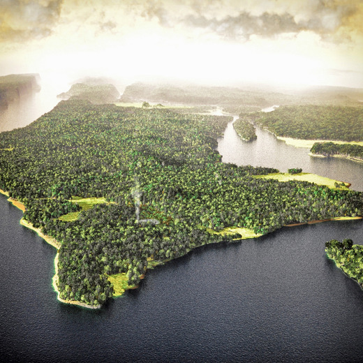 [Credit: Sharon Hahn Darlin, Flickr.com]
I toured the exhibit on a rainy Friday afternoon last October, on its very last day.
At the center of the exhibit hall was a three-dimensional model of Manhattan island. Projectors above displayed maps onto the model, showing where streams once ran, where the Lenape camped, and where the beavers lived. And when I walked back across the northern reaches of Central Park, I could see it.
Maybe it's just because I live in the uplands of Morningside Heights, but I think the key to the success of that map was its three-dimensionality. The Mannahatta web site hosts an interactive version (more on that another time), but it's just not as evocative. On the model, I could imagine myself at the crest of Morningside Park, looking across open plains.
So many of our graphics are intended to be consumed on a flat surface. What becomes possible when we open up a third dimension? It's something I'm pondering.
Anyway. When I was at the museum, a tall man in a National Park Service uniform was taking measurements of the three-dimensional Mannahatta map, so I hold dear to the hope that it will resurface at some historic site someday soon.